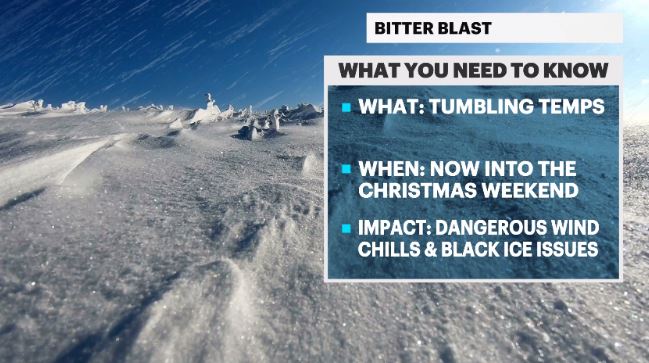
BITTER BLAST: Tumbling temps and dangerous wind chills for holiday weekend
News 12 Storm Watch Team Meteorologist Addison Green says tumbling temperatures and dangerous wind chills will be around for the whole Christmas weekend.
•
Dec 23, 2022, 10:01 AM
•
Updated 772 days ago
Share:
More Stories
0:46

BPU withdraws from fourth round of bidding for NJ offshore wind projects
3h ago2:28

Passengers at Newark Liberty warned of delays due to air traffic control staff shortages
4h ago2:35

Ice skating community holds vigil to honor those lost in American Airlines crash
4h ago
Lawmakers criticize Gov. Murphy for comment that seemed to suggest he would house non-citizen
4h ago2:15

Newark man charged under enhanced penalties for home invasion and car theft
4h ago0:17

Authorities capture sex offender inmate who escaped medical transport van
4h ago0:46
BPU withdraws from fourth round of bidding for NJ offshore wind projects
3h ago2:28
Passengers at Newark Liberty warned of delays due to air traffic control staff shortages
4h ago2:35
Ice skating community holds vigil to honor those lost in American Airlines crash
4h agoLawmakers criticize Gov. Murphy for comment that seemed to suggest he would house non-citizen
4h ago2:15
Newark man charged under enhanced penalties for home invasion and car theft
4h ago0:17
Authorities capture sex offender inmate who escaped medical transport van
4h agoWHAT'S NEW: The arctic cold front has passed and completely swung open the freezer door for us on Long Island with temps falling quickly and to dangerous levels.
WHAT'S NEXT: This will be a very cold Christmas weekend and we don't really thaw out until mid week next week. New Year's Eve and Day though is looking milder but comes along with a chance of rain showers.
News 12 Storm Watch Team Meteorologist Addison Green says tumbling temperatures and dangerous wind chills will be around for the whole Christmas weekend.
FORECAST:
OVERNIGHT: Strong winds and chilly air continue to invade the island. Feels Like: sub zero. Avg. Low: 28. Lows: mid-0s to low-10s.
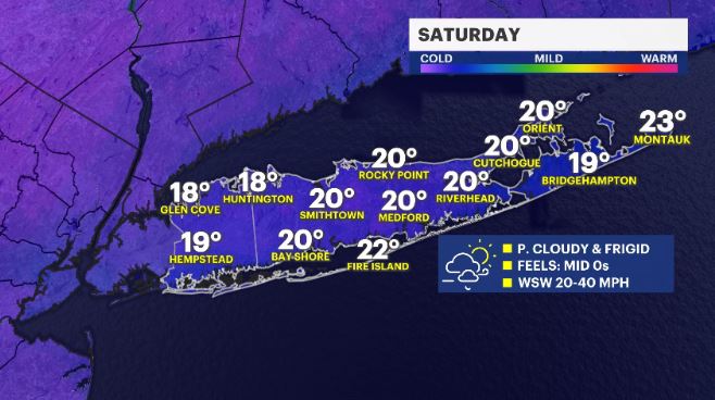
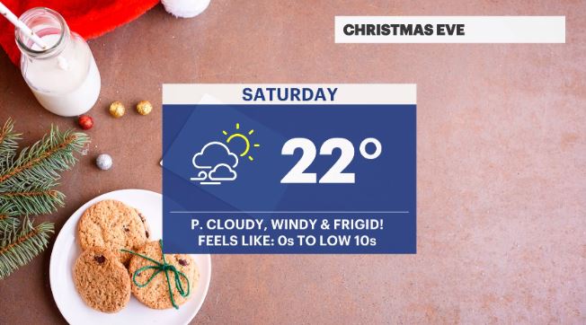
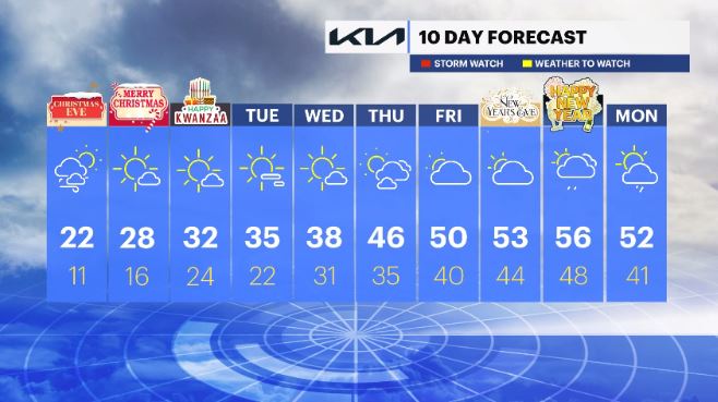
SATURDAY: CHRISTMAS EVE – BITTER BLAST - Partly cloudy, windy and feeling FRIGID! The eastern half of the island may see a few snow showers. Feels Like: mid-singles to low-10s. Avg. high: 42. Highs: low-20s. Lows: low- to mid-10s.
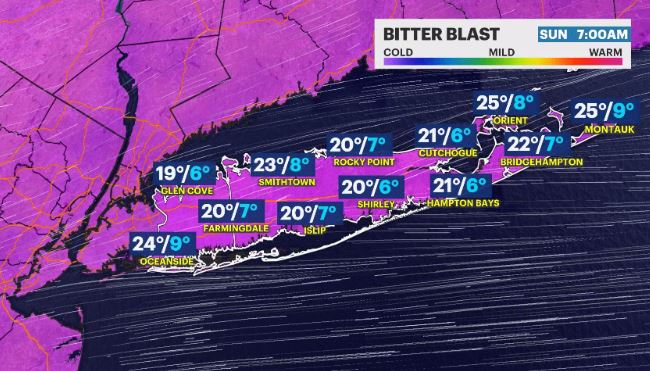
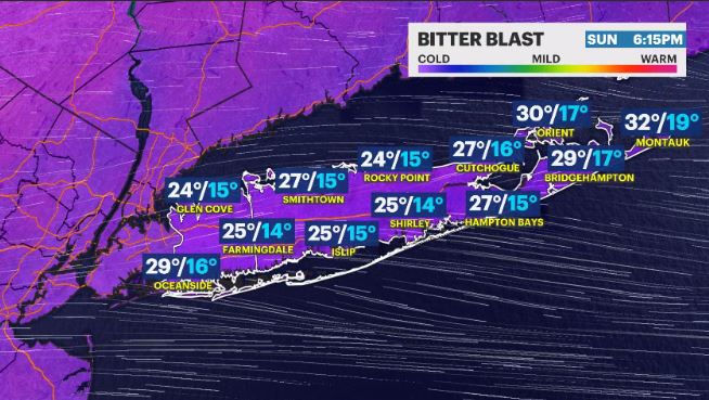
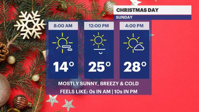
SUNDAY: CHRISTMAS DAY – BITTER BLAST - Mostly Sunny and still chilly. Feels Like: mid-10s. Highs: upper-20s. Lows: upper-10s.
MONDAY: KWANZAA BEGINS – Sunny out with less breezy winds and still trending below average. Feels Like: mid-20s. Highs: upper-20s to low-30s. Lows: Mid-20s.
TUESDAY: Lots of sun and a lingering deep chill with less wind around. Highs: upper-30s. Lows: upper-20s to low-30s.
WEDNESDAY: Partly cloudy with a light breeze. Highs: upper-30s. Lows: Upper-20s to low-30s.
THURSDAY: A mix of sun and clouds and feeling seasonable. Highs: Low- to mid-40s. Lows: Mid-30s.
FRIDAY: Mostly sunny to partly cloudy and feeling MUCH better. Highs: upper-40s to low-50s. Lows: Upper-30s to low-40s.
SATURDAY: NEW YEAR'S EVE – Mostly cloudy with a chance for scattered showers. Highs: Low- to mid-50s. Lows: Mid-40s.
Sunday: NEW YEAR'S DAY – Mainly cloudy with scattered showers. Highs: Mid-50s. Lows: Mid- to upper-40s.
MONDAY: Scattered shower chances linger. Highs: Upper-40s to low-50s. Lows: Upper-30s to low-40s.
More from News 12
2:24

Windy and milder Monday in New Jersey; snow squall possible Tuesday
1:26

Teaneck uses drones to monitor snow removal
1:50

Planets continue to parade across the night sky
2:32

Big Easy, Big Snow: More snow fell in NOLA than in Newark all winter
1:54

Residents tell News 12 their apartment hasn’t had heat in nearly two weeks
1:06
