STORM WATCH: Heavy rain and rough surf headline Monday's forecast
Showers and thunderstorms become widespread on Monday with periods of heavy rain, while dangerous surf and life-threatening rip currents create hazardous beach conditions.
More Stories


What to expect:
Showers and thunderstorms increase overnight, becoming widespread Monday.
Periods of heavy rain could lead to localized flooding, especially Monday afternoon.
Dangerous surf and a high risk of rip currents develop at Atlantic beaches Monday.
Drier weather returns Tuesday before additional shower chances arrive later Wednesday into Friday.
Seasonable temperatures continue through the week.
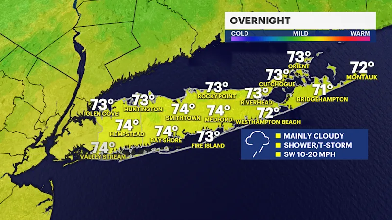
Overnight (Lows: Lower 70s)
Clouds increase with showers and thunderstorms becoming more numerous during the evening and overnight. While rainfall will initially be scattered, steadier and heavier rain develops overnight as a slow-moving storm system approaches.
Monday (Highs: Lower 80s)
Periods of showers and thunderstorms continue through much of the day. Some storms will produce heavy downpours capable of reducing visibility and creating ponding on roads. Localized flooding is possible where the heaviest rain persists. Winds will also become gusty near stronger thunderstorms.
Monday Night (Lows: Upper 60s)
Showers and thunderstorms gradually diminish during the evening, with skies beginning to partially clear overnight as the cold front moves offshore.
Tuesday (Highs: Lower 80s)
A much quieter day with a mix of sunshine and clouds, comfortable humidity, and dry weather returning.
Tuesday Night (Lows: Upper 60s)
Partly to mostly cloudy and dry with comfortable overnight temperatures.
Wednesday (Highs: Lower 80s)
Partly sunny with increasing clouds. Most of the day remains dry, although another unsettled weather pattern begins developing later in the day.
Wednesday Night (Lows: Around 70)
Partly cloudy with only a slight chance of a passing shower late.
Thursday (Highs: Mid-80s)
Mostly sunny and warm for much of the day. A few showers may develop Thursday night as another disturbance approaches.
Friday (Highs: Mid-80s)
Partly sunny with scattered showers possible at times as the unsettled pattern lingers.
Weather alerts, watches, and hazards
Heavy Rain and Localized Flooding (Late Tonight through Monday):
Periods of moderate to heavy rain are expected with widespread rainfall totals generally between 1 and 2 inches, with isolated higher amounts possible. Rainfall rates may exceed 1 inch per hour in the heaviest downpours, leading to localized flooding of poor drainage areas, urban roadways, and low-lying locations. While widespread flash flooding is not expected at this time, isolated flooding remains possible.
Thunderstorms (Late Tonight through Monday):
Embedded thunderstorms will accompany the rain. Most storms will remain below severe limits, but a few stronger storms could produce gusty winds, frequent lightning, and torrential rainfall.
High Surf (Monday):
Building southerly swells may create breaking waves of 6 to 9 feet along Atlantic-facing beaches. Rough surf will make entering the ocean extremely dangerous, and a High Surf Advisory may be needed.
High Risk of Rip Currents (Monday):
A strengthening southerly swell will create dangerous, life-threatening rip currents at Atlantic beaches. Even experienced swimmers can quickly become caught in these powerful currents. The safest choice is to stay out of the surf if you are not swimming at a beach staffed by lifeguards.
Additional Rain Chances Later This Week:
After dry weather returns Tuesday, another frontal boundary may bring additional showers and a few thunderstorms from Wednesday night through Friday. While details remain uncertain, periods of unsettled weather are likely to return before improving next weekend.