
Back-to-back storms? There’s weather to watch this weekend in the tri-state
Long-range weather computer models suggest a large winter storm system could develop near the tri-state area, though timing, track and impacts are highly uncertain at this time.
More Stories


Could the tri-state area be in for another winter storm this coming weekend, one week after Sunday's significant snow and ice storm?
News 12’s meteorologists are monitoring early indications that another system could take shape. The forecast remains highly fluid this far out, however.
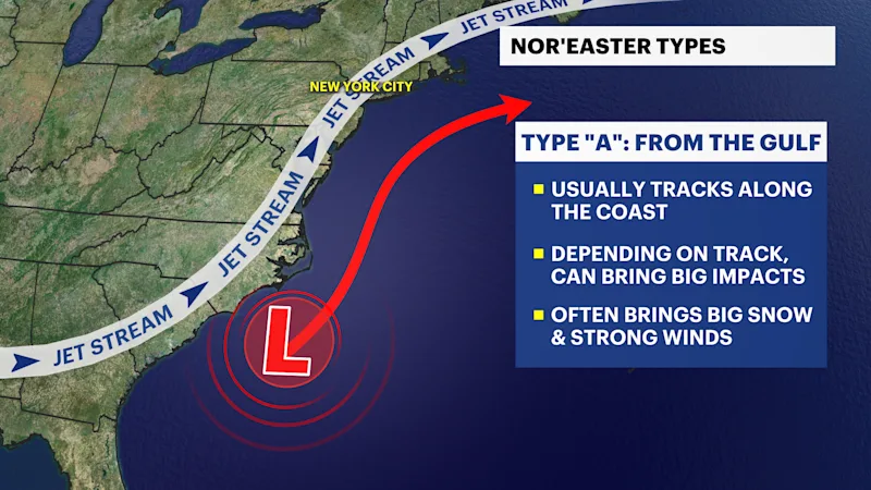
THE SCENARIOS
A large-scale cold weather pattern continues to dominate much of the eastern United States following the high-impact winter weather on Sunday and Monday. That initial setup can sometimes support additional storm development along the East Coast.
Some long-range scenarios loosely resemble what is defined as a "Miller A" type storm system – a classic coastal storm that forms in the southern U.S. and tracks northward, occasionally bringing widespread precipitation if conditions align.
“It’s been over 10 years since we’ve seen back-to-back storms, so this week is going to be very important,” News 12 meteorologist Michele Powers said. “Staying with News 12 will be key as we continue to learn more about this weekend’s potential and fine-tune the forecast.”
TIME WILL TELL
Being more than four days away from this potential storm, even small shifts in the jet stream could dramatically change the outcome — ranging from snow or mixed precipitation to a weaker system or even a complete miss. For now, this remains a feature to watch rather than a forecast, with more meaningful details expected to emerge later in the week as models gain better resolution.


