Hour-by-hour forecast: Thunderstorms move across New Jersey
Thunderstorms are currently moving across New Jersey.
•
Jul 28, 2020, 9:44 AM
•
Updated 1,542 days ago
Share:

Thunderstorms are currently moving across New Jersey.
Hourly radar forecast
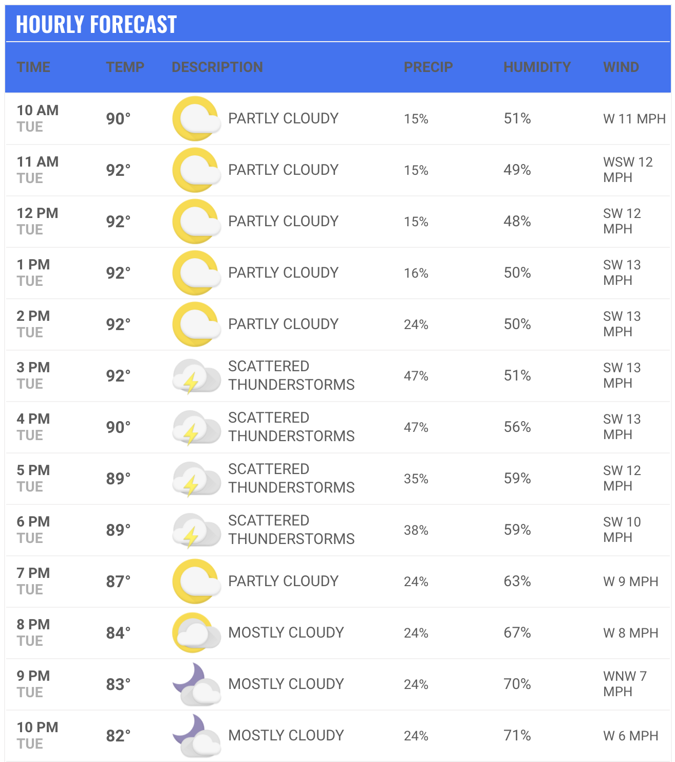
News 12 New Jersey Meteorologist Dave Curren says that the storms will produce drenching rains with lots of thunder and lightning. But Curren says that the storms are not expected to be as bad as the thunderstorms earlier this month.
Curren says that the storms will produce a lot of rain, leading to some flooding potential. Winds also have the potential to reach 40-50 mph. But Curren says that the storms are not expected to produce hail or threats of tornados.
Temperatures Tuesday remained in the 90s, as they have been for the past several days around the state. Humid conditions made temperatures feel as if they were much warmer. Heat advisories remain in place for most of the state.
MORE: Cooling centers around the tri-state area
MORE: 15 tips to help you save energy and money during peak demand
MORE: 12 tips to help keep your pets cool during the dog days of summer
MORE: 12 cool tips to help you stay healthy during a heat wave
MORE: 15 tips to help you save energy and money during peak demand
MORE: 12 tips to help keep your pets cool during the dog days of summer
MORE: 12 cool tips to help you stay healthy during a heat wave

The storms are expected to be a threat through the overnight hours but will clear out by Wednesday morning.
Wednesday will see a mix of sun and clouds with high temperatures around 92 degrees. Overnight temperatures are expected to cool slightly to the mid-70s.
Thursday will see hazy, hot and humid conditions, with a chance for a late-day thunderstorm. High temperatures will be around 94 degrees.
More from News 12
2:00

All East Orange schools to run on half-day schedule on Friday following heated meeting with officials
2:53

Autumn air sticks around for one more day in New Jersey
1:08

ANCHOR benefit website down until Oct. 23 for maintenance
1:43

JCP&L: Squirrel causes power outage in Monmouth County for 2nd time in as many months
0:30

Prosecutor: 2 nursing assistants accused of critically injuring patient in assault
0:40
